print, engraving
#
comic strip sketch
#
pen drawing
# print
#
pen sketch
#
old engraving style
#
personal sketchbook
#
geometric
#
pen-ink sketch
#
pen work
#
sketchbook drawing
#
history-painting
#
storyboard and sketchbook work
#
sketchbook art
#
engraving
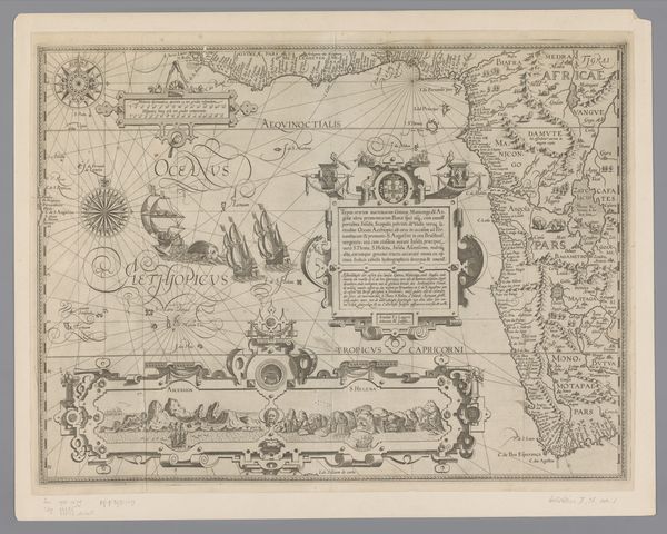
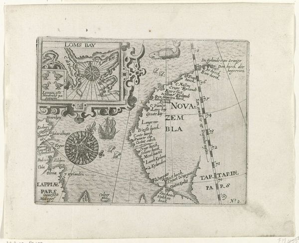
Dimensions: height 138 mm, width 184 mm
Copyright: Rijks Museum: Open Domain
Curator: Here we have a map titled "Kaartje van Nova Zembla, 1597," created sometime between 1615 and 1617. It's an engraving, part of the Rijksmuseum's collection. What strikes you first about it? Editor: It’s like looking at a fever dream about exploration! All these swirling lines and cramped text, ships bravely venturing into what seems like a watery abyss… kind of anxiety-inducing, but also compelling. Curator: Maps from this era are fascinating cultural artifacts. Note the detailed depictions of sea monsters, sailing ships, and elaborate compass roses. They weren't just about geographical accuracy; they were potent symbols of power, knowledge, and the unknown. Editor: The compass roses feel almost like talismans, guiding spirits as much as navigational tools. I imagine those sailors clinging to this map, the engraving a tangible link between their known world and this icy, alien landscape. Nova Zembla, it looks utterly forbidding, beautiful but…inhospitable. Curator: Indeed. The symbolism is rich. The whale, the ships battling unknown currents... it speaks to both the resources they sought and the perilous nature of those early voyages. These images are ingrained deeply in the European imagination of this era. Editor: I love that. And all those little seals along the bottom there—a touch of playfulness amid all the high stakes. Almost a sense that nature herself is watching these adventurers, with bemusement. Curator: The "unknown" was as much psychological as it was geographical. Mapping uncharted territory required a different kind of faith, a willingness to confront not just the elements but the limits of their own understanding. Editor: Absolutely. Looking at it now, I find myself considering the contemporary drive to map everything. Are we still grappling with a fundamental "unknown" even now, with satellites and sensors, or have we lost that visceral sense of exploration that defines the age of this map? Curator: That's a very interesting point. This engraving is not just a document; it represents a pivotal moment in how humans saw, and sought to conquer, the world. Editor: Makes you wonder what our "maps" will look like to those in the future looking back on our age of exploration and discovery. Food for thought!
Comments
No comments
Be the first to comment and join the conversation on the ultimate creative platform.
More like this