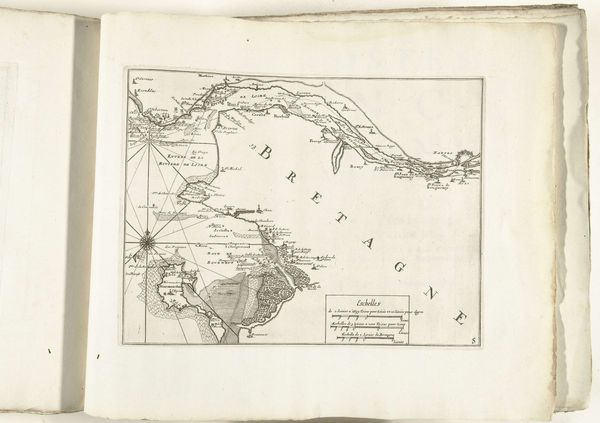
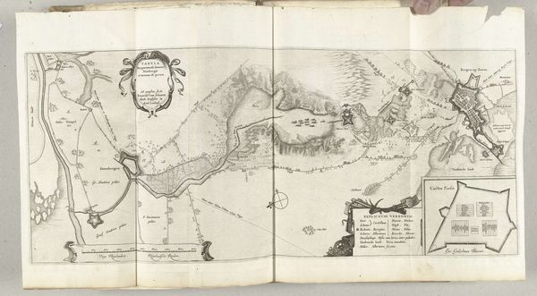
Kaart van de Franse westkust met de monding van de Garonne en Dordogne, ca. 1702 1702 - 1703
0:00
0:00
anonymous
Rijksmuseum
drawing, print, paper, ink, engraving
#
drawing
#
baroque
#
mechanical pen drawing
# print
#
pen sketch
#
old engraving style
#
landscape
#
paper
#
personal sketchbook
#
ink
#
sketchwork
#
pen-ink sketch
#
pen work
#
sketchbook drawing
#
storyboard and sketchbook work
#
sketchbook art
#
engraving
Dimensions: height 229 mm, width 330 mm
Copyright: Rijks Museum: Open Domain
Editor: This engraving from around 1702-1703 depicts a map of the French west coast with the Garonne and Dordogne river mouths. The precision of the lines is quite striking; it makes me wonder about the purpose it served. How do you interpret this work? Curator: This isn't just a map; it's a record of labor, of material resources harnessed for a specific purpose. Look closely at the precision of the engraving – that demanded skilled craftsmanship and specialized tools. It represents investment in exploration, navigation, and very possibly, colonial expansion. Who funded this project, and for what economic gain? Editor: So, beyond just geography, you're suggesting that it speaks to trade routes and perhaps resource exploitation? Curator: Exactly. The map's function transcends simple representation; it enables resource extraction and commercial activity. What paper was used? Where did the ink come from? The materiality speaks volumes about the global networks at play. The production itself, the very act of creation, required resources and infrastructure. We can assume this particular printing, due to its high quality, would have been circulated among wealthier merchants. Editor: That's fascinating, the way the materials themselves become part of the story. It makes me think about how the consumption of the art reinforces those systems as well. It’s not just about looking at a place; it’s about owning that knowledge. Curator: Precisely. Its dissemination reinforces the power dynamics inherent in cartography at the time, both enabling and reinforcing patterns of trade, conflict, and governance. I think you’re on your way to challenging art-historical conventions which value artistic intention independently of these economic contexts! Editor: Thanks, this has really broadened my understanding; now I want to dig deeper into the political context that shaped its creation. Curator: Indeed, let’s further research those supply chains!
Comments
No comments
Be the first to comment and join the conversation on the ultimate creative platform.
More like this