print, engraving
#
dutch-golden-age
# print
#
old engraving style
#
landscape
#
geometric
#
line
#
cityscape
#
engraving
Dimensions: height 170 mm, width 380 mm
Copyright: Rijks Museum: Open Domain
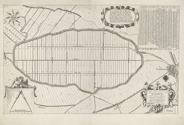
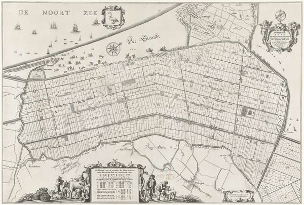
Curator: Before us hangs "Kaart ter voorbereiding van de inpoldering van de Haarlemmermeer", a fascinating print made around 1640-1642 by Gerard Coeck. Editor: It’s immediately striking – so meticulously gridded. It reminds me of early urban planning sketches, an almost utopian vision rendered in delicate lines. There is something very appealing to the geometric nature of the planned land reclamation, and in the stark contrast to the organic shapes around the area. Curator: Exactly! This map wasn't just a representation of geography; it was an instrument of power and a projection of ambition. The Haarlemmermeer, a large lake that had caused significant flooding, was seen as a problem to be solved and the dutch applied an urge of control over water. This print symbolizes that mentality, an early stage of a long, complex political and engineering process, showing the start of land reclamation project with the goal to increase agriculture and protect settlements. Editor: Thinking purely formally, I'm drawn to the intricate line work. It gives a very concrete sense of what kind of control can look like – creating something precise and planned and using something with an aesthetic element, not quite purely pragmatic in function or aesthetics. How fascinating that an engraving, usually associated with artistic reproduction, served here as an official document and propaganda piece! Curator: It speaks volumes about the social context. The Dutch Golden Age was marked by innovation, exploration and a growing mercantile power. Land reclamation was central to this, an example of the state and private citizens joining forces and engaging with cutting edge science of that period. These images boosted their confidence and collective ambition. Editor: It is true, I'm struck by how clearly and effectively information is transmitted. A strong aesthetic design gives the whole thing impact and gravitas, suggesting the inevitability of this enterprise. It’s far from the cold austerity that often comes with "official" documentation. Curator: This map truly goes beyond its simple function; its beauty becomes a persuasive tool, legitimizing a large intervention on a historic level. Viewing "Kaart ter voorbereiding van de inpoldering van de Haarlemmermeer", helps in understanding about our past, the impact of cartography, and about societal hopes. Editor: And for me, seeing such rigorous detail overlaid on what was then a still uncertain landscape emphasizes both the confidence and maybe even the anxieties around such a large undertaking. This isn't just a map; it's a very artful assertion of dominance.
Comments
No comments
Be the first to comment and join the conversation on the ultimate creative platform.
More like this