drawing, print, ink, engraving
#
drawing
#
baroque
# print
#
ink
#
geometric
#
cityscape
#
engraving
Dimensions: height 211 mm, width 284 mm
Copyright: Rijks Museum: Open Domain
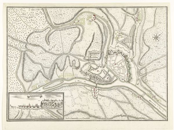
Curator: Here we have a Vestingplattegrond van Oudenaarde, or Fortified Map of Oudenaarde, an anonymous print and ink drawing from approximately 1700 to 1726. It’s part of the Rijksmuseum's collection. Editor: My immediate impression is one of precision and control. The city looks almost like a geometric puzzle, tightly wound and heavily defended. Curator: Precisely. These plans weren’t just about geography; they were instruments of power. Consider the historical context: Oudenaarde was strategically vital in the County of Flanders, caught between various European powers. These fortifications are not just about defense, but also about asserting control in a volatile region. Editor: Visually, all those sharp angles forming the bastions—they speak to a period preoccupied with warfare. But even beyond that, there is something symbolically assertive in the visual language of the map itself. The intricate network of walls and waterways suggests resilience. Curator: It’s interesting that you pick up on the waterways, which highlight the area's history with trade. The map blends elements of military strategy with commercial concerns. I see how it embodies early modern statecraft. These maps become tools in consolidating power. Editor: The very act of mapping has symbolic importance, staking claim to territory and knowledge. Beyond strategy, there is a psychological element here. Projecting dominance to anyone viewing it, which makes it much more than just functional planning. It tells of ambition. Curator: And who was viewing these things and when. It really makes me wonder about that sphere and the political tensions. What was the process for creating and then storing this material for the purpose it would serve the powers at hand. Editor: I never thought about how it could connect us, too. That history echoes now, too, from artist to beholder. Curator: Exactly. The map invites us to consider what imagery means when placed in broader power dynamics. Editor: Ultimately, seeing the city mapped in this manner, knowing the layers of history intertwined, transforms my perception entirely. It’s really thought-provoking.
Comments
No comments
Be the first to comment and join the conversation on the ultimate creative platform.
More like this