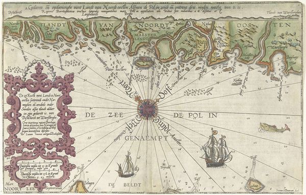
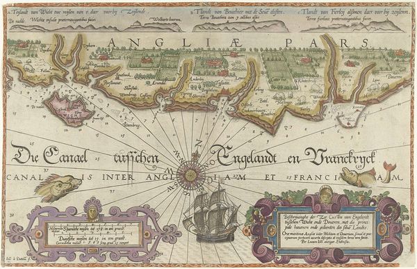
Kaart van de kust van Zweden tussen Kalmar en Stockholm 1580 - 1583
0:00
0:00
joannesvanidoetechum
Rijksmuseum
drawing, print, paper, engraving
#
drawing
#
pen drawing
# print
#
pen illustration
#
pen sketch
#
landscape
#
paper
#
11_renaissance
#
personal sketchbook
#
pen-ink sketch
#
pen work
#
sketchbook drawing
#
genre-painting
#
storyboard and sketchbook work
#
northern-renaissance
#
sketchbook art
#
engraving
#
intricate and detailed
Dimensions: height 330 mm, width 507 mm
Copyright: Rijks Museum: Open Domain
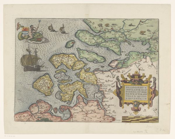
Curator: At first glance, this feels like peering into the personal sketchbook of a Renaissance explorer—it's raw and exciting. I love the slightly haphazard lettering sprinkled around the page. Editor: You've hit on something key. What we are looking at here is *Kaart van de kust van Zweden tussen Kalmar en Stockholm*, a pen and ink drawing by Joannes van (I) Doetechum, dating from about 1580 to 1583. It resides in the collection of the Rijksmuseum. Curator: 16th century! Incredible. Maps from this time weren’t just navigational tools, right? They were like portable worldviews. I’m drawn to the monsters swimming about. Is there one with lion paws? I mean what’s the cultural thinking behind their inclusion? Editor: The sea monsters definitely capture the imagination. Their presence highlights the unknown, turning geographical representation into a tapestry of both observed reality and imagined dangers. These are visualizations of potential threats, but perhaps also a nod to the sublime terror and mystery of the oceans that were very real to the people. Curator: The radial lines are magnetic as well. Are they just markers of distance or wind? Also, this map seems to indicate both actual harbors and depths—I mean, its creator clearly spent some time on location, no? Editor: Precisely. They represent lines of magnetic variation from a central point and certainly show the use of then-cutting edge navigational understanding. But these maps often included valuable depth soundings. And absolutely! Someone ventured out on these waters, with keen observations converted into visual form. The details of coastal features point to first-hand survey work, meticulously transferred into this medium. Curator: A visual blend of science and story. Something of the deep soul of our journey as a species reflected in lines, measurements, beasts, and water. A reminder that we're still mapping new territories within ourselves. Editor: Beautifully put. This map reveals not only a coastline but also a mindset—an age where exploration meant confronting the real and the imagined.
Comments
No comments
Be the first to comment and join the conversation on the ultimate creative platform.
More like this