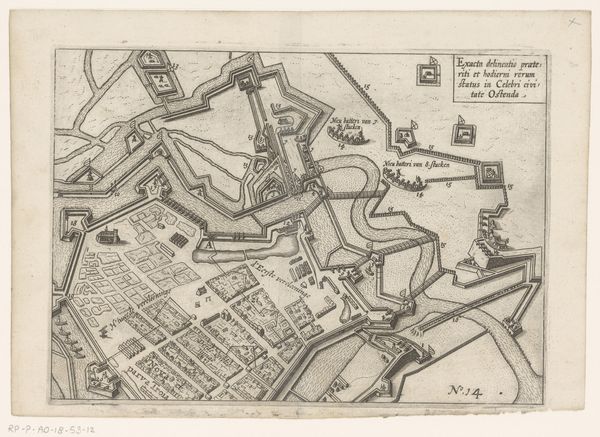
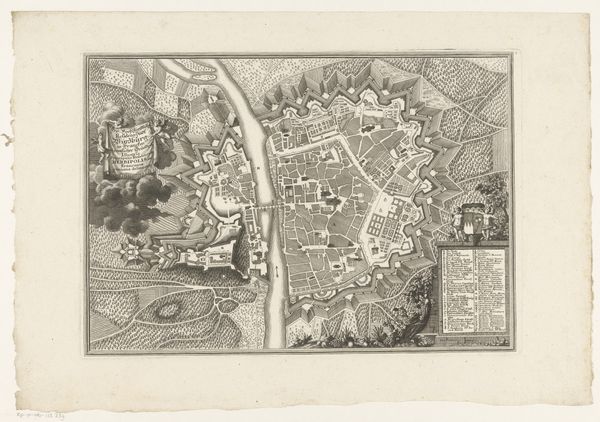
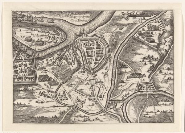
Beleg van Oostende: de afsnijdingen en het Nieuwe Troje, 1604 1604 - 1615
0:00
0:00
anonymous
Rijksmuseum
print, ink, engraving
#
pen drawing
# print
#
landscape
#
perspective
#
ink
#
line
#
cityscape
#
history-painting
#
engraving
Dimensions: height 174 mm, width 225 mm
Copyright: Rijks Museum: Open Domain
Curator: Today, we're observing a detailed print held at the Rijksmuseum, titled "Beleg van Oostende: de afsnijdingen en het Nieuwe Troje, 1604," which translates to "The Siege of Ostend: the cuttings and the New Troy, 1604." It dates from 1604 to 1615 and is the work of an anonymous artist. What strikes you first about it? Editor: The overwhelming feeling is of intense strategic calculation—this is a landscape rendered as a chessboard. There's a chilling dispassion in the meticulous lines documenting military positioning; the human element seems utterly secondary to the geometries of power. Curator: Indeed. As an iconographer, I am intrigued by the city’s renaming to "New Troy," evoking the mythical siege. The allusion adds a layer of historical and symbolic weight. Ostend's resistance is thereby framed within a larger narrative of struggle and perhaps even doomed heroism, resonating with timeless themes of warfare and resistance. Editor: Precisely, but who gets to be cast as the hero and who becomes the vanquished? Consider the sociopolitical context: this siege, part of the Eighty Years' War, saw the Dutch Republic fighting for independence from Spanish rule. Naming a besieged Dutch city "New Troy" could align Spanish aggression with that of the Greeks and recast the defenders of Ostend as virtuous victims, albeit at a great human cost. The imagery certainly serves a propaganda function. Curator: The image also offers compelling clues to its intent through its use of cartographic language to influence and inspire through both documented accuracy and imagined, almost mythical potentiality. Consider the symbolism inherent within lines, which appear throughout history and cross-culturally as representing borders, divisions, or limitations; a map, much like religious iconography, aims to offer insight into a greater truth, influencing through its symbolism a collective idea or action. Editor: Agreed. The seemingly objective birds-eye view is itself a political act. Who is afforded this perspective? Rulers, strategists, those in positions of authority and power. Its visual language reinforces their dominance even within what appears to be a relatively accessible, informative document. This level of accessibility belies its very powerful rhetorical intentions. Curator: Understanding that kind of visual rhetoric deepens our comprehension, wouldn’t you agree? It brings forth how artistic depictions carry layered meanings that extend far beyond their immediate aesthetic appeal. Editor: Absolutely. By critically examining this image through both its visual cues and the power dynamics it implies, we are able to see how such cartographic illustrations were instrumental in shaping opinions and mobilizing populations during times of conflict, revealing that even maps aren't neutral documents.
Comments
No comments
Be the first to comment and join the conversation on the ultimate creative platform.
More like this