print, paper, engraving
#
comic strip sketch
#
imaginative character sketch
#
quirky sketch
#
baroque
# print
#
landscape
#
cartoon sketch
#
paper
#
personal sketchbook
#
idea generation sketch
#
sketchwork
#
sketchbook drawing
#
cityscape
#
history-painting
#
storyboard and sketchbook work
#
sketchbook art
#
engraving
Dimensions: height 237 mm, width 274 mm
Copyright: Rijks Museum: Open Domain
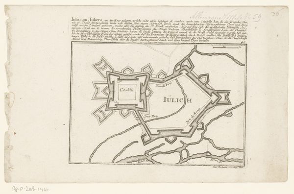
Editor: So, this is 'Plattegrond van Genéve,' an engraving on paper made sometime between 1701 and 1733 by Abraham Allard. It's currently at the Rijksmuseum. Looking at it, it reminds me of those elaborate board games where you’re planning a siege! All those fortified points! What do you see when you look at this piece? Curator: I see more than just a map, I see a dance. Look at the fluid lines tracing the Rhône river, snaking its way through the city. It is as if the river is dictating the very shape and rhythm of Geneva. The city becomes a body responding to the currents, don't you think? Imagine living here when this map was made. Would you have felt a similar harmony or something else? Editor: Hmm, I'm not sure if I'd use the word "harmony," given the fortifications. Seems more like anxiety about invaders! Curator: Maybe! But consider: the sharp angles of those fortifications, repeated again and again. Are they merely defensive? Or are they almost decorative? Like precise folds of origami around the heart of the city. There is a real sense of order amid the implied chaos, you know? Allard seems almost in love with his subject. I think if you are open, you might see what he sees, perhaps… Editor: I never thought about it that way! Now, when I look again, there's definitely a... repetition. Like a visual rhyme. It makes the whole city seem kind of deliberate and artistic. Curator: Exactly! I think we’ve only begun to scratch the surface, so thanks for being here! Editor: Agreed! Always something new to learn about how art is done. Thanks.
Comments
No comments
Be the first to comment and join the conversation on the ultimate creative platform.
More like this