Dimensions: image: 360 x 362 mm support: 360 x 362 mm frame: 597 x 584 x 25 mm
Copyright: © Rita Donagh | CC-BY-NC-ND 4.0 DEED, Photo: Tate
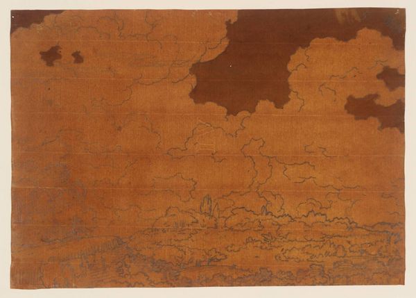
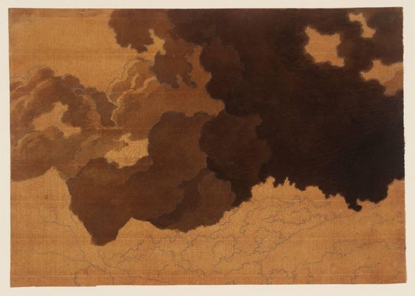
Curator: Rita Donagh’s "shadow of six counties (c)" presents us with a map, its surface treated with washes and erasures. My immediate sense is one of instability and fragility. Editor: The map is of Northern Ireland, and the obscuring whites really emphasize a sense of imposed boundaries, and the erasure of identities inherent in political division. Curator: Exactly. Maps are powerful symbols; they define territories, and in turn, identities. The washes almost seem to be actively dismantling that imposed order. The title itself, "shadow of six counties", evokes a past presence and loss. Editor: Right, these visual acts really speak to the complexities of power and representation, especially when a map becomes a site of contention. Who gets to draw the lines, and who gets erased? Curator: Precisely. In that sense, the act of partially obscuring the map can be read as an act of resistance, reclaiming agency over the representation of place and identity. Editor: It’s a potent commentary on the politics of space, isn’t it? Seeing it this way makes me think about how art can reveal the human cost of such divisions.
Comments
tate 12 months ago
⋮
http://www.tate.org.uk/art/artworks/donagh-shadow-of-six-counties-c-t12291
Join the conversation
Join millions of artists and users on Artera today and experience the ultimate creative platform.
tate 12 months ago
⋮
Created by the British artist Rita Donagh, shadow of six counties (c) 1980 consists of a square road map of Northern Ireland featuring a large central area demarcated in pencil and partially shaded in blue and grey, with the areas surrounding it unevenly coated in white paint that obscures some of the printed locations. The ‘six counties’ referred to in the title collectively form Northern Ireland (Antrim, Armagh, Derry, Down, Fermanagh and Tyrone). The demarcated area replicates the combined shape (or ‘shadow’, as the title implies) of the six counties – the shape of Northern Ireland as a whole – but it is drawn onto the map on a magnified section of an area in the east of Northern Ireland, around Belfast. As such, some areas that in reality lie within the six counties, such as Armagh, appear in this work to be outside the borders that Donagh has created. There are creases visible in the work, some further emphasised by the paint, which are suggestive of folds in the map.
More like this