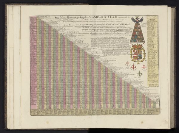
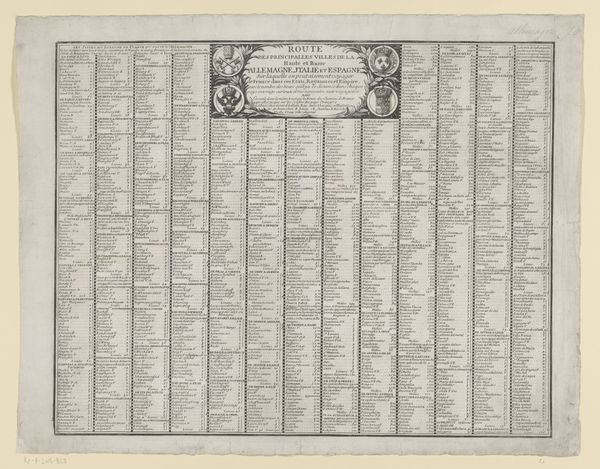
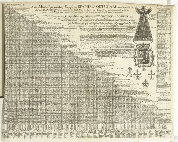
Afstandstabel voor belangrijke steden uit Staats-Brabant, de Zuidelijke Nederlanden en Noord-Frankrijk tot aan Parijs 1708
0:00
0:00
print, engraving
#
baroque
# print
#
geometric
#
geometric-abstraction
#
line
#
cityscape
#
engraving
Dimensions: height 519 mm, width 590 mm
Copyright: Rijks Museum: Open Domain
Curator: This is Claude Gournay's "Afstandstabel voor belangrijke steden uit Staats-Brabant, de Zuidelijke Nederlanden en Noord-Frankrijk tot aan Parijs," a table of distances between major cities printed in 1708. Editor: It hits me like a spreadsheet from a Wes Anderson film. Immaculate, organized… utterly charming. Curator: Indeed. The baroque sensibilities are apparent in the ornamentation of the title cartouche. But consider how Gournay synthesizes data presentation with artistic flourish through line and limited coloration. Editor: It feels both pragmatic and playful. I love how this object, probably made for traders, evokes journeys, adventures. It even tells small, human stories of its day. Curator: That’s right, one could say the city names act as signifiers—nodes within a broader network, geographically and conceptually. The grid becomes the stage where early 18th-century commerce plays out. Editor: I'm also thinking about how different people would look at this chart. Imagine some stuffy old accountant finding it beautifully efficient, compared to a love-struck merchant dreaming of their paramour along the trade route? Curator: That contrast in interpretation showcases the inherent tensions within representational art – that of fact versus meaning. This engraving succeeds by existing on both planes. Editor: Maybe it’s about transforming navigation itself into an act of creation? Drawing your destiny through interconnected spaces? The geometry becomes more than mere coordinates; they symbolize fate itself. Curator: Yes! Looking closely, observe how meticulously Gournay organized disparate geographic spaces via an intelligible system of distances. In that organization, we locate inherent Enlightenment values. Editor: It makes me want to travel; to feel lost in a landscape… Perhaps the beauty is in embracing that unknowability? After all, charts get redrawn, borders shift... Curator: Maps may become obsolete but, their artistic representation of the spatial relationships remains ever compelling. Editor: Beautifully put. In the end, isn't it all art – commerce, love, and even war. And isn’t this chart proof?
Comments
No comments
Be the first to comment and join the conversation on the ultimate creative platform.
More like this