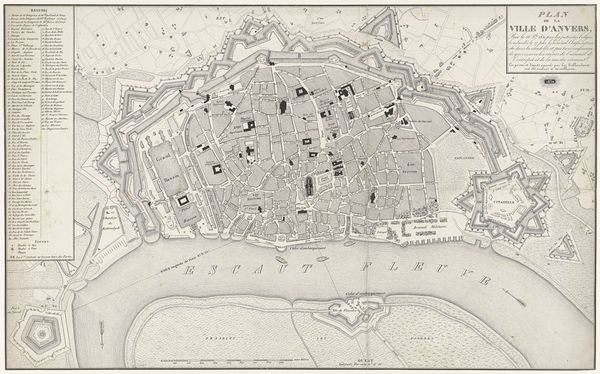
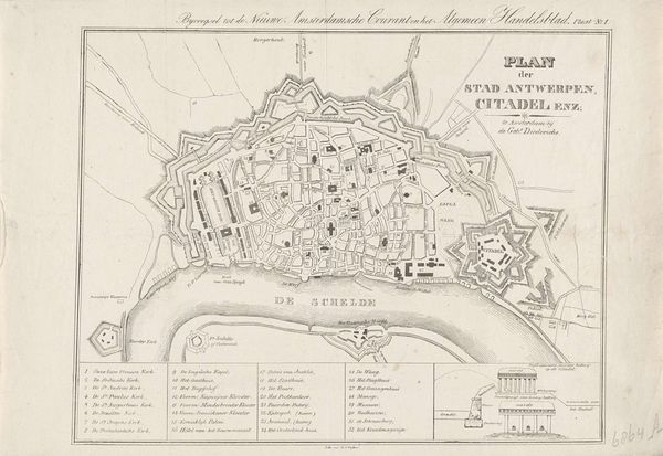
Kaart van Antwerpen met de stelling der Vijandelijke Armee, van den 12 December 1832 1832 - 1833
0:00
0:00
anonymous
Rijksmuseum
drawing, print, paper, ink, pen
#
drawing
# print
#
pen illustration
#
paper
#
ink line art
#
ink
#
sketchwork
#
geometric
#
pen
#
cityscape
#
history-painting
Dimensions: height 285 mm, width 451 mm
Copyright: Rijks Museum: Open Domain
Curator: Here we have an intriguing cartographic drawing, “Kaart van Antwerpen met de stelling der Vijandelijke Armee, van den 12 December 1832,” or “Map of Antwerp with the Position of the Enemy Army, from December 12, 1832." Created circa 1832-1833, its author is anonymous. It combines pen, ink, and print on paper, currently residing at the Rijksmuseum. What strikes you about it? Editor: The intricacy is captivating! It feels very formal, even sterile, until you consider the subject matter: a city under siege. I immediately see a network, carefully planned, and subtly menacing in its detail. Curator: Maps have always held power as symbolic representations of territory and control. Here, Antwerp is not merely depicted; it’s presented as a contested space. What can the imagery of fortification, the "stelling" or position of enemy armies, tell us about collective anxiety during that era? Editor: It’s fascinating how geometric precision overlays a narrative of conflict. Those lines and angles weren't just about geography; they represented political boundaries, social divisions, and military strategies. Notice how the key identifies strategic points—moats, redoubts—almost as if deciphering a code. Curator: Exactly! The symbols, beyond their practical purpose, tap into deeper cultural understanding of defense, power, and threat. Consider the repeated shapes—the fortresses resemble eyes watching, reminding us of a constant state of vigilance. It’s a visual language understood even by those who couldn’t read the labels. How do you read that river splitting through the composition? Editor: The river Schelde bisects the city but it is also part of its defense. Antwerp's fate is linked to that waterway—a source of commerce, but also vulnerability. We see little boats near the riverbanks and, it appears like the drawing intends to give the viewer some insight into its complex and tumultuous history. Curator: The inclusion of those small ships subtly directs the viewer towards a broader perspective. They signify potential routes of attack, but also continued commerce and connection even amid conflict. It creates an emotional undercurrent of resilience, even survival, persisting beneath the documented aggression. Editor: So, beyond its function as a historical document, the piece evokes these ideas of power, conflict, and resilience that have resonance even today. It also sparks my curiosity, making me think about what symbols of our own cities today may hold and represent in the future. Curator: Precisely. Through understanding this anonymous cartographer’s choice of line, symbol, and layout, we unearth how a simple map can speak volumes about the cultural and emotional landscape of its time.
Comments
No comments
Be the first to comment and join the conversation on the ultimate creative platform.
More like this