drawing, print, etching
#
drawing
# print
#
etching
#
landscape
#
river
#
cityscape
#
history-painting
#
realism
Dimensions: height 165 mm, width 204 mm
Copyright: Rijks Museum: Open Domain
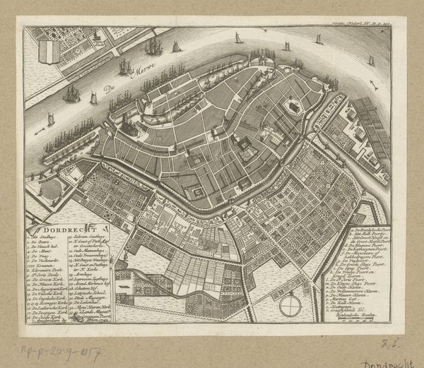
Curator: We’re looking at “Plattegrond van de stad Utrecht,” or "Map of the City of Utrecht," a print created by Daniël Stopendaal around 1790, currently held at the Rijksmuseum. It's rendered in etching and drawing. Editor: It strikes me immediately as incredibly precise. The density of line work and geometric structuring creates a powerful sense of order and control, reflecting the values of the period, I suppose. Curator: Indeed. Its historical context is fascinating. This map offers insight into urban planning and military strategy during the late 18th century. Note the fortifications; Utrecht was a strategically important city, and maps like these were crucial for defense. Also, consider the social implications; the wealthy lived within the city walls, controlling trade. Editor: Beyond that socio-political element, look at the arrangement of the graphic components: The placement of the title, the compass rose, the keyed legends… These features act as entry points, shaping how viewers navigate the intricate details, guiding our gaze to create a specific experience. Curator: Right, but this particular layout emphasizes legibility and practical use. While aesthetic considerations were surely present, functionality seems paramount. Stopendaal provides more than just spatial data; he embeds ideologies about civic order. You could speculate about how a city presented itself, projected an image of stability through precise documentation. Editor: Agreed, yet I also see it aesthetically; the composition itself presents a unified system where each line contributes to the whole. The variation in line thickness provides depth, hinting at architectural structures while still retaining an element of abstraction, reducing elements to shapes on paper. Curator: And if we broaden our historical frame, it ties in to the burgeoning Enlightenment emphasis on reason, empiricism. Mapping as a tool for understanding, classifying the world, a manifestation of power… This print isn't just a map. It's a visual document. Editor: This print is as much about representing knowledge, order and clarity. Examining this from multiple views gives new ways of comprehending historical contexts and spatial relations within our present day. It almost demands the modern world’s attention.
Comments
No comments
Be the first to comment and join the conversation on the ultimate creative platform.
More like this