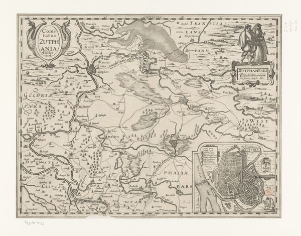
Kaart van het graafschap Moers en van het Rijnland, 1610 1591 - 1595
0:00
0:00
joannesmercator
Rijksmuseum
drawing, print, ink, engraving
#
drawing
#
dutch-golden-age
# print
#
pen illustration
#
pen sketch
#
old engraving style
#
landscape
#
11_renaissance
#
ink
#
geometric
#
pen work
#
engraving
Dimensions: height 358 mm, width 243 mm, height 361 mm, width 501 mm
Copyright: Rijks Museum: Open Domain
Editor: This is "Kaart van het graafschap Moers en van het Rijnland, 1610" by Joannes Mercator, made sometime between 1591 and 1595. It's an intricate map composed of engraving and ink, giving it an almost ethereal, antique feel. The detail is incredible. What catches your eye about this work? Curator: You know, what really gets me about maps of this era is imagining Mercator himself, hunched over, fueled by candlelight and a thirst for geographic clarity, painstakingly etching these lines. It's a dance between art and science, isn’t it? I’m immediately drawn to the way he portrays the landscape, those swirling rivers that feel almost alive. Look at how the trees are depicted—not just blobs of green, but individual characters in this regional drama. I wonder, does this provoke in you a sense of wanderlust, the kind of longing they might have felt setting off into the unknown? Editor: Definitely. The rivers feel like arteries, and the settlements like tiny, purposeful gestures on a larger body. Is that a visual language of the period, to see landscape as so deeply intertwined? Curator: Exactly! Maps weren't just about directions; they were statements of power, identity, and understanding. Think of who this was made for: powerful landowners, merchants needing routes. Also look at those cartouches. Aren't they fabulous, sort of visual proclamations? So ornate. Editor: It makes you think about the power of visual representation, about who gets to define the narrative on the land. Curator: Absolutely. Maps have stories. Now, how has seeing this influenced how you view your place on the map? Has it perhaps triggered a sense of curiosity about its deep history, or stirred the romantic longing for journeys into uncharted territories? Editor: For sure, it’s given me a new appreciation for how maps blend practicality and artistic expression. I'm curious to research the individual towns named on it. Thanks so much!
Comments
No comments
Be the first to comment and join the conversation on the ultimate creative platform.
More like this