drawing, print, ink, engraving
#
drawing
#
narrative-art
#
baroque
# print
#
landscape
#
ink
#
geometric
#
cityscape
#
history-painting
#
engraving
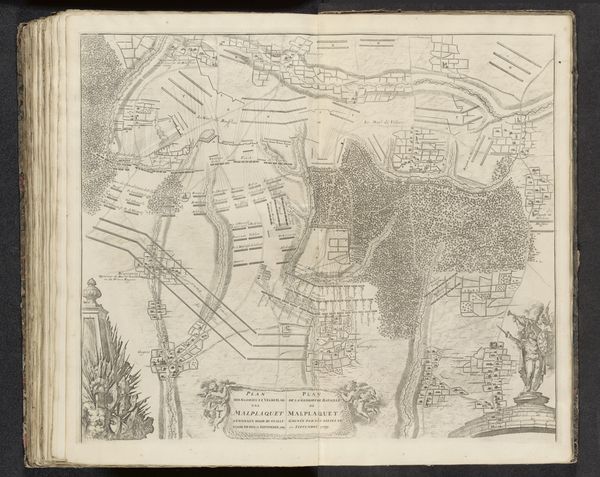
Dimensions: height 469 mm, width 580 mm
Copyright: Rijks Museum: Open Domain
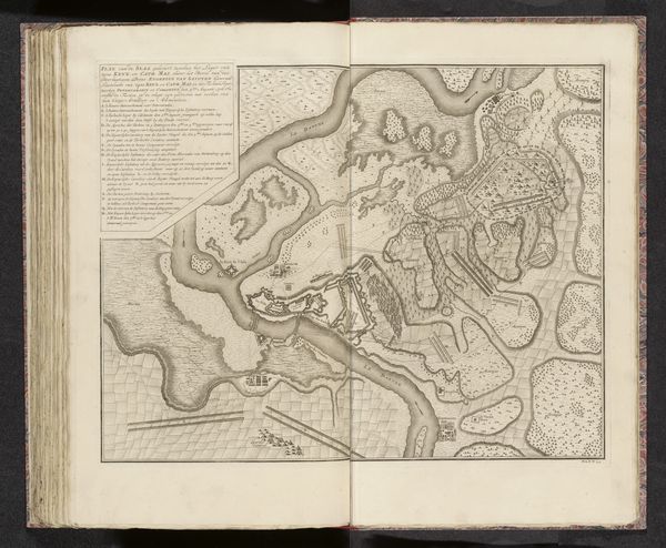
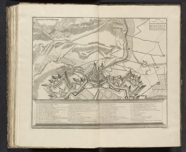
Curator: This is an engraving titled *Ontzet van Turijn, 1706*, created between 1706 and 1729. It's currently held in the Rijksmuseum. It shows, in meticulous detail, the city of Turin and the surrounding battle lines. What strikes you about it at first glance? Editor: The detail is astounding! It feels almost like an exercise in precision. All those tiny lines making up this cityscape; and you can discern a definite geometric quality from the layout, with a series of triangles branching outward. Curator: Exactly! The use of geometric shapes helps convey power dynamics through strategic city planning, showing the efforts to claim and defend land. Consider also Turin's position as a site of contestation for Savoyard identity amidst shifting alliances. This image captures not just a moment of military action, but reflects larger cultural tensions. Editor: Yes, but the artist has not taken liberties. The very act of mapping can impose a controlling gaze onto a space. The cool detachment and precise rendering creates a world that, while chaotic in the events it portrays, has a sense of compositional order. It makes complex events understandable through visual logic. Curator: Absolutely, we see this detachment reflected in how the figures are depersonalized. The anonymous profile flattens the lived experiences of those impacted by the siege. Their subjectivities, their trauma - absent, silenced in service to grand narratives of power. It reminds us of the importance of interrogating the "official" story being presented. Editor: Agreed, but I would also say that despite the artist’s anonymity and commitment to topography, the sweeping diagonals imply energy. There is a clear formal language to understand what exactly is happening through the composition. There is tension inherent in the stark contrast between city’s stable form and the invading chaos! Curator: And those details provide fertile ground to examine the narratives we’ve inherited. How conflict reshapes landscapes—and lives—both in that era, and our own. This map invites questions around who creates, controls, and benefits from visualizing historical conflict. Editor: It offers us a structured lens into the past. It’s been fascinating looking at this, not only in terms of its artful rendering but for what it may represent.
Comments
No comments
Be the first to comment and join the conversation on the ultimate creative platform.
More like this