drawing, print, etching, ink
#
drawing
#
light pencil work
#
quirky sketch
#
dutch-golden-age
# print
#
pen sketch
#
etching
#
landscape
#
personal sketchbook
#
ink
#
sketchwork
#
ink drawing experimentation
#
geometric
#
pen-ink sketch
#
sketchbook drawing
#
storyboard and sketchbook work
#
sketchbook art
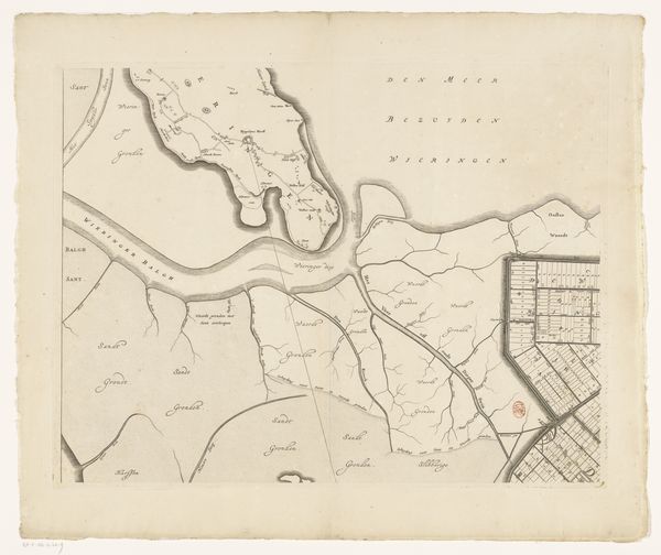
Dimensions: height 412 mm, width 851 mm
Copyright: Rijks Museum: Open Domain
This is Frederik de Wit's map of the Koegras polder, made at an unknown date, in the Netherlands. It presents us with more than just geography; it's a window into the ambitions and societal structures of its time. Consider the term 'polder'. This artificially reclaimed land, which can be seen throughout the map, represents a feat of engineering prowess and a testament to the Dutch Republic's relentless pursuit of expansion and control over its environment. It highlights the dynamic relationship between the Dutch and their landscape, one defined by constant negotiation and intervention. The very act of mapping transforms the physical world into a symbolic territory, staking a claim and asserting ownership. To fully understand this map, historians delve into archives, studying land reclamation projects, engineering techniques, and legal frameworks governing land ownership. This reveals that art, like this map, is always embedded in social and institutional contexts.
Comments
No comments
Be the first to comment and join the conversation on the ultimate creative platform.
More like this