print, etching, engraving
# print
#
etching
#
landscape
#
history-painting
#
engraving
Dimensions: height 274 mm, width 413 mm
Copyright: Rijks Museum: Open Domain
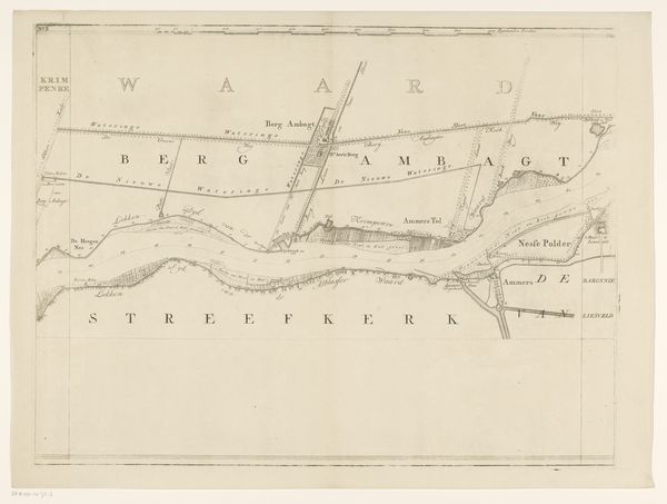
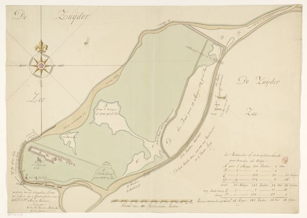
Curator: Before us we have a print from 1809, titled "Kaart van dijkdoorbraak onder Loenen," a work documenting a dike breach near Loenen. It seems to be the creation of an anonymous artist. Editor: The etching feels so controlled, almost scientific. I’m struck by the evenness of the lines, suggesting meticulous craftsmanship and probably a fairly repeatable process. Curator: Absolutely, prints such as this would have been reproduced in quantity at the time. I see more than just land and water; the visual language reveals a very specific cultural memory— the ever-present Dutch struggle against the sea, now etched into the collective psyche. Editor: The very act of mapping implies an assertion of control, doesn't it? Even if the event depicted signifies a temporary loss. It highlights the vulnerability inherent in manipulating nature. Consider the ink, the paper itself: each material signifies a different stage in the transformation of the landscape into an idea. Curator: You speak of control, and it makes me reflect upon our human place in these cycles of building, breaching, and rebuilding. The visual elements used to portray nature are highly conventional, stylized—yet they attempt to convey an authentic disaster. Do you think this tension influences the viewers’ experience? Editor: Certainly. The print’s limitations—the two-dimensionality, the restricted tonal range of the etching process itself—become metaphors for our limited ability to ever fully represent or manage something so inherently powerful as a major flood. Curator: It serves as a stark reminder that nature’s power can undo human constructions and reshape perceived boundaries in the literal landscape but also, potentially, in the human consciousness itself. What the imagery triggers for those remembering it is what creates its longevity. Editor: The transformation from natural disaster into consumable information, sold in prints, is another crucial aspect. It changes our perception. An engraving renders an extraordinary experience mundane through mass distribution and repeated engagement. I suppose that could be said of much art. Curator: Yes, and in turn transforms it to a symbolic rendering of history—a map leading viewers through loss, resilience and adaptation. Editor: Well, examining the artistic process offers its own way into the cultural significance of it, doesn’t it? A sort of alternate route for the eye and the mind.
Comments
No comments
Be the first to comment and join the conversation on the ultimate creative platform.
More like this