print, paper, engraving
dutch-golden-age
ink paper printed
old engraving style
paper
geometric
history-painting
engraving
Dimensions: height 328 mm, width 230 mm
Copyright: Rijks Museum: Open Domain
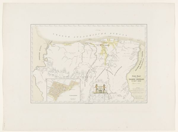
This is an undated map of Kaap de Goede Hoop (Cape of Good Hope) made by an anonymous artist. It presents an intricate rendering of geographical space through a muted palette of pinks, creams, and browns. A rectilinear grid underscores the map, emphasizing its constructed nature. What strikes me is the tension between scientific representation and artistic expression. The delicate lines delineating the coastline and topographical features attempt to provide a clear, objective view. Yet, the soft colors and detailed embellishments disrupt any notion of pure objectivity. The map becomes a semiotic system, where each element acts as a sign. Coastlines, place names, and territorial markers are not merely descriptive, but are culturally and politically charged. Ultimately, the grid asserts control over the unknown, transforming it into structured, measurable space. Yet, this ordering exists alongside the map's aesthetic qualities, its colors and illustrative elements that resist total rationalization. This tension highlights how maps are not just tools for navigation, but are complex cultural artifacts shaping how we perceive and interact with the world.
Comments
No comments
Be the first to comment and join the conversation on the ultimate creative platform.