About this artwork
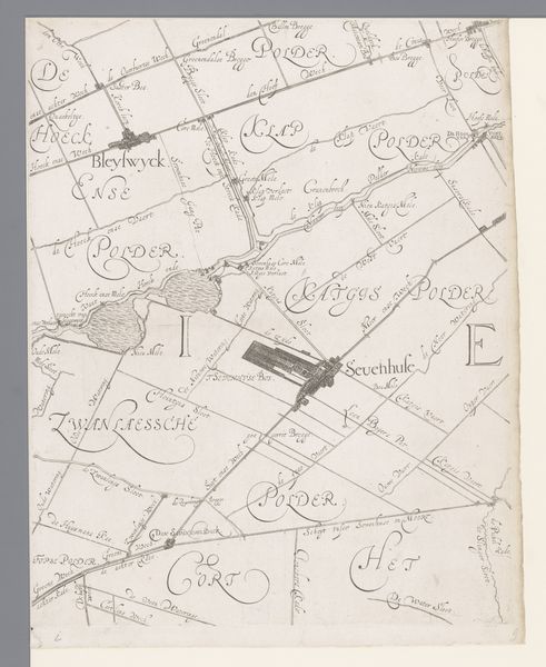
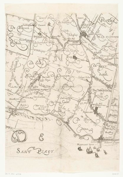
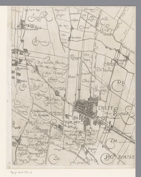
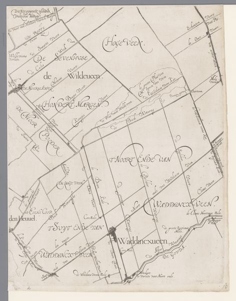
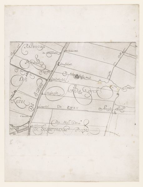
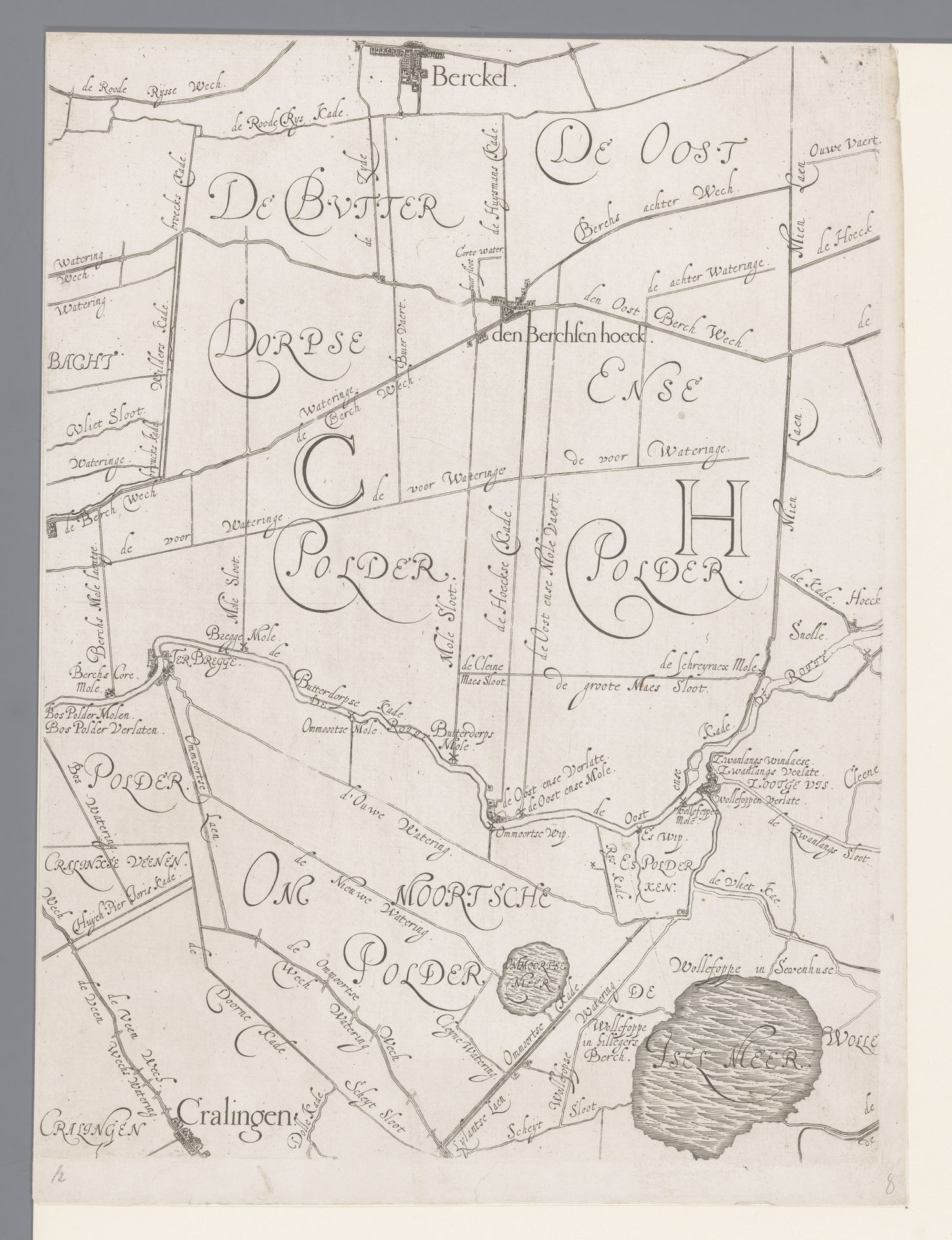
Curator: This is a map, "Kaart van het Hoogheemraadschap van Schieland, met Berkel en Bergschenhoek," created sometime between 1611 and 1635 by Floris Balthasarsz van Berckenrode. It’s rendered in pen and ink on paper. Editor: It strikes me as remarkably clean, almost diagrammatic. There's a stark elegance in its simplicity—a landscape distilled down to lines and lettering. It feels surprisingly modern, even now. Curator: Maps are powerful tools for visualizing space but also asserting control. What this map communicates, to me, is a cultural obsession with land management, especially water. Consider "Hoogheemraadschap," referring to a water board, an authority ensuring dry feet and fertile fields. This region of Schieland, dotted with polders—those reclaimed low-lying lands—tells a story of the Dutch mastering their environment, wresting land from the sea through dikes and canals. You can see them meticulously marked here. Editor: Yes, these almost delicate lines become conduits, visually channeling power. The polders named in elegant script, and defined by linear borders, appear almost as separate symbolic kingdoms. Note the careful variance in line weight defining structures and territories. It reveals a clear hierarchy of significance within the landscape, not unlike that used in music notation to indicate importance. Curator: Absolutely. Each marking carries the weight of countless hours of labor. Think of the windmills—symbols of Dutch ingenuity—driving pumps to drain these areas. Each name is not merely a label, but an embodiment of the region's complex legal and social organization, with ancient roots, based on how they drained excess water from these specific lands, using sluices or pumping mills. These places were part of the cultural fabric of their age, their presence, preserved in symbols, reflecting pride, achievement, and mastery of the environment. Editor: In a sense, the map’s artistry resides in how efficiently it conveys that intricate system through line, shape, and text. A testament to the power of design. This efficient visual organization has aged exceptionally well! Curator: The visual vocabulary that this cartographer created provides more than wayfinding alone. It’s a window into how people understood their relationship with their lands centuries ago, a heritage still felt in Holland to this day. Editor: Looking at this, I see how such seemingly functional objects can also offer such beautiful insights. Thank you!
Kaart van het Hoogheemraadschap van Schieland, met Berkel en Bergschenhoek
1611 - 1635
Floris Balthasarsz van Berckenrode
1562 - 1616Location
RijksmuseumArtwork details
- Medium
- drawing, paper, ink, pen
- Dimensions
- height 386 mm, width 290 mm
- Location
- Rijksmuseum
- Copyright
- Rijks Museum: Open Domain
Tags
Comments
Share your thoughts
About this artwork
Curator: This is a map, "Kaart van het Hoogheemraadschap van Schieland, met Berkel en Bergschenhoek," created sometime between 1611 and 1635 by Floris Balthasarsz van Berckenrode. It’s rendered in pen and ink on paper. Editor: It strikes me as remarkably clean, almost diagrammatic. There's a stark elegance in its simplicity—a landscape distilled down to lines and lettering. It feels surprisingly modern, even now. Curator: Maps are powerful tools for visualizing space but also asserting control. What this map communicates, to me, is a cultural obsession with land management, especially water. Consider "Hoogheemraadschap," referring to a water board, an authority ensuring dry feet and fertile fields. This region of Schieland, dotted with polders—those reclaimed low-lying lands—tells a story of the Dutch mastering their environment, wresting land from the sea through dikes and canals. You can see them meticulously marked here. Editor: Yes, these almost delicate lines become conduits, visually channeling power. The polders named in elegant script, and defined by linear borders, appear almost as separate symbolic kingdoms. Note the careful variance in line weight defining structures and territories. It reveals a clear hierarchy of significance within the landscape, not unlike that used in music notation to indicate importance. Curator: Absolutely. Each marking carries the weight of countless hours of labor. Think of the windmills—symbols of Dutch ingenuity—driving pumps to drain these areas. Each name is not merely a label, but an embodiment of the region's complex legal and social organization, with ancient roots, based on how they drained excess water from these specific lands, using sluices or pumping mills. These places were part of the cultural fabric of their age, their presence, preserved in symbols, reflecting pride, achievement, and mastery of the environment. Editor: In a sense, the map’s artistry resides in how efficiently it conveys that intricate system through line, shape, and text. A testament to the power of design. This efficient visual organization has aged exceptionally well! Curator: The visual vocabulary that this cartographer created provides more than wayfinding alone. It’s a window into how people understood their relationship with their lands centuries ago, a heritage still felt in Holland to this day. Editor: Looking at this, I see how such seemingly functional objects can also offer such beautiful insights. Thank you!
Comments
Share your thoughts