drawing, ink
#
drawing
#
baroque
#
ink
#
cityscape
#
watercolor
Dimensions: height 200 mm, width 263 mm
Copyright: Rijks Museum: Open Domain
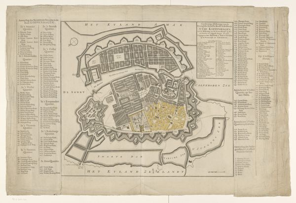
This anonymous map shows Copenhagen after the devastating fire of 1728. It was made sometime after the event, with pen, ink, and watercolor. Copenhagen in the 18th century was a city caught between its medieval past of timber-framed buildings and its aspirations to be a modern, fortified capital. The fire, which destroyed a large portion of the city, becomes a stark reminder of this tension. Maps like this were not just records; they were instruments of power. They served as tools for urban planning and reconstruction, reinforcing the authority of the state and reshaping the city to prevent future disasters. The map highlights the areas destroyed, but also the city’s fortifications. To fully appreciate this map, you could look at fire insurance records, city planning documents, and architectural treatises from the period. Through this, we can understand the map not only as a depiction of a disaster, but as a document of social and institutional change.
Comments
No comments
Be the first to comment and join the conversation on the ultimate creative platform.
More like this