About this artwork
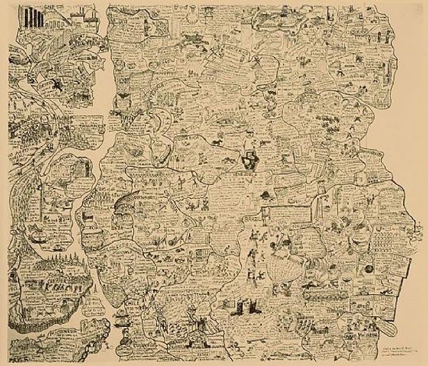
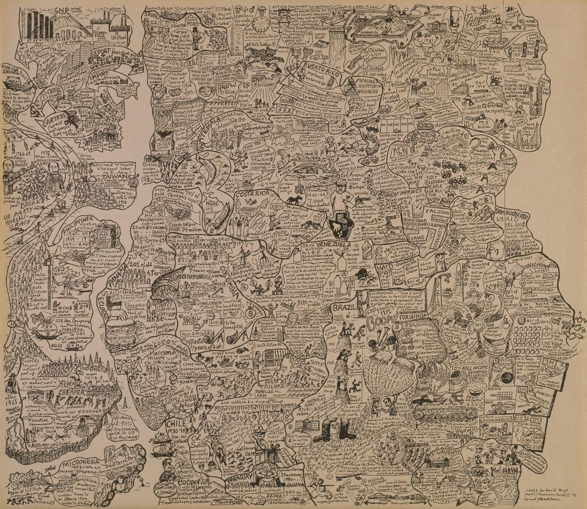
Editor: Here we have Oyvind Fahlstrom's "Sketch for World Map Part 1," showing the Americas and Pacific. It's undated, but it's densely packed with information and imagery. What’s your take on Fahlstrom's artistic process here? Curator: The medium itself—pen and ink on paper—speaks to accessibility, a DIY approach to critiquing power structures. What kind of labor went into it? It's about the production and dissemination of information, challenging who gets to define global narratives. Editor: So, the act of mapping itself is being questioned? Curator: Precisely. Think about the paper as a commodity, the ink's origins, the labor needed to create these materials. The dense imagery becomes a form of consumption, a visual overload reflecting the bombardment of information in modern society. What systems are in play? Editor: I didn't initially see it that way, but understanding the materiality makes the message much clearer. Curator: Exactly! By focusing on the "how" and "what" of its making, we uncover Fahlstrom's commentary on global economics.
Sketch for World Map Part 1 (Americas, Pacific)
1972
Artwork details
- Dimensions
- image: 887 x 1022 mm
- Location
- Tate Collections
- Copyright
- © All Rights Reserved, DACS 2014 | CC-BY-NC-ND 4.0 DEED, Photo: Tate
Comments
http://www.tate.org.uk/art/artworks/fahlstrom-sketch-for-world-map-part-1-americas-pacific-p78630
Fahlström’s map of the Americas and the Pacific Rim represents the economic, military and political forces shaping the region rather than its physical geography. The combination of political radicalism and irreverent, cartoon-like style reflects Fahlström’s admiration for the underground comics of the 1960s. He described the work as ‘a historical map of the world, approx. 1970. Most of it is about the Third World: economic exploitation, repression, liberation movements. ...The shapes of the countries are defined by the data about them.’ Gallery label, November 2006
About this artwork
Editor: Here we have Oyvind Fahlstrom's "Sketch for World Map Part 1," showing the Americas and Pacific. It's undated, but it's densely packed with information and imagery. What’s your take on Fahlstrom's artistic process here? Curator: The medium itself—pen and ink on paper—speaks to accessibility, a DIY approach to critiquing power structures. What kind of labor went into it? It's about the production and dissemination of information, challenging who gets to define global narratives. Editor: So, the act of mapping itself is being questioned? Curator: Precisely. Think about the paper as a commodity, the ink's origins, the labor needed to create these materials. The dense imagery becomes a form of consumption, a visual overload reflecting the bombardment of information in modern society. What systems are in play? Editor: I didn't initially see it that way, but understanding the materiality makes the message much clearer. Curator: Exactly! By focusing on the "how" and "what" of its making, we uncover Fahlstrom's commentary on global economics.
Comments
http://www.tate.org.uk/art/artworks/fahlstrom-sketch-for-world-map-part-1-americas-pacific-p78630
Fahlström’s map of the Americas and the Pacific Rim represents the economic, military and political forces shaping the region rather than its physical geography. The combination of political radicalism and irreverent, cartoon-like style reflects Fahlström’s admiration for the underground comics of the 1960s. He described the work as ‘a historical map of the world, approx. 1970. Most of it is about the Third World: economic exploitation, repression, liberation movements. ...The shapes of the countries are defined by the data about them.’ Gallery label, November 2006