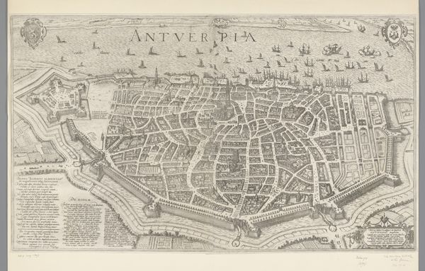
Plattegrond van Antwerpen; intocht van Ferdinand te Antwerpen in 1635 (nr. 42) 1639 - 1641
0:00
0:00
drawing, paper, ink
#
drawing
#
dutch-golden-age
#
mechanical pen drawing
#
pen sketch
#
perspective
#
paper
#
personal sketchbook
#
linework heavy
#
ink
#
sketchwork
#
geometric
#
pen-ink sketch
#
thin linework
#
pen work
#
sketchbook drawing
#
cityscape
#
history-painting
#
initial sketch
Dimensions: height 458 mm, width 762 mm
Copyright: Rijks Museum: Open Domain
Theodoor van Thulden created this print of Antwerp in 1635 to commemorate a state visit. It shows us how maps can be so much more than records of geographical space. The bird’s eye view presents the city as orderly and prosperous, closely bounded by its defensive walls. Yet this image belies the complex political reality of the time. Antwerp was part of the Spanish Netherlands, and the ‘Ferdinand’ celebrated in the title was a Cardinal-Infante of Spain. The visit was intended to reinforce Spanish rule after decades of war with the Dutch Republic. The map thus presents a picture of power. These kinds of prints were often commissioned by the political elite, designed to shape public perception. As historians, we need to look beyond the image itself, examining archives and other historical sources to understand the full story behind it. Only then can we appreciate the complex interplay between art, power, and society.
Comments
No comments
Be the first to comment and join the conversation on the ultimate creative platform.
More like this