print, engraving
landscape
geometric
engraving
Dimensions: height 1012 mm, width 1234 mm
Copyright: Rijks Museum: Open Domain
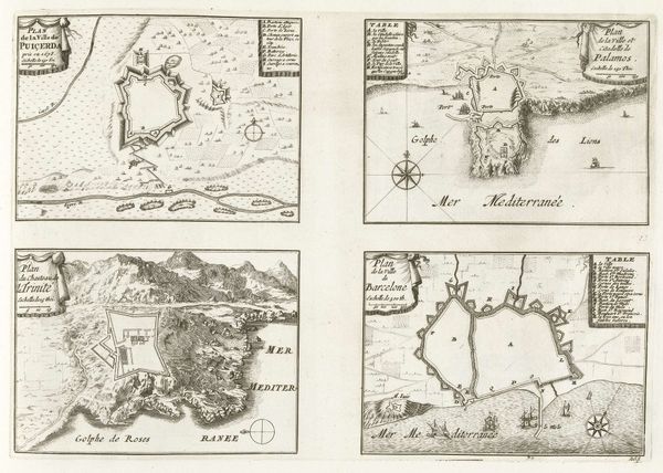
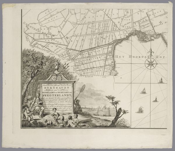
Editor: This is "Kaart van het dijkgraafschap Drechterland, bestaande uit vier delen," a map from 1775. It appears to be an engraving or print of the Dutch region, divided into four sections. What strikes me is how it combines these practical geographic depictions with decorative elements, like coats of arms and little ships. How do you interpret the visual language here? Curator: The visual language is so interesting because it speaks of both power and pragmatism. The coats of arms act as symbols of authority, declaring ownership and control over the land. What emotional impact do you feel when you see those symbols placed above a map of a reclaimed territory? Editor: It feels almost celebratory, like claiming dominion over the land is something to be proud of, and I feel slightly conflicted given the long-term consequences of those environmental changes. I am also interested by the little sailing ships surrounding the region, especially since this is a low lying region below sea level and extremely reliant on its waterways for transportation. Curator: Indeed! They're almost like guardians or active participants in maintaining the region’s prosperity. And note the image of everyday citizens included on the bottom left square. It’s not just about geography, it also evokes the social structure that upholds it. Do you notice the presence of similar allegorical themes in other historical maps you’ve studied? Editor: Yes, absolutely! Many incorporate symbolic imagery reflecting the culture’s values and its relationship with the land, like ancient maps placing their nation in the center, both physically and spiritually. This feels similar to the cultural values on display in this region's relation to its waters. Curator: Exactly. Recognizing these symbols opens a deeper understanding. We aren't just looking at a map, we're witnessing a cultural narrative being etched into the landscape. Editor: This really changes how I see the relationship between art and cartography. The map isn't merely functional; it’s actively shaping the cultural memory. Curator: Precisely, the visual language here invites us to see the layers of history and human interaction encoded within. It becomes more than a geographic guide. It mirrors our culture.
Comments
No comments
Be the first to comment and join the conversation on the ultimate creative platform.