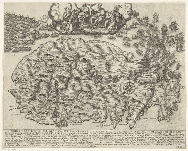
Kaart van de landen in het Noord-Oosten van de Middellandse Zee 1603 - 1604
0:00
0:00
baptistavandoetechum
Rijksmuseum
graphic-art, print, etching, engraving
#
graphic-art
#
baroque
# print
#
pen sketch
#
etching
#
old engraving style
#
history-painting
#
engraving
Dimensions: height 293 mm, width 495 mm
Copyright: Rijks Museum: Open Domain
Curator: This piece, "Kaart van de landen in het Noord-Oosten van de Middellandse Zee," created around 1603-1604, comes to us from Baptista van Doetechum. What are your initial thoughts on this map? Editor: The density is immediately striking! It feels almost overwhelmingly detailed. There's an incredible texture created by the dense engraving, lending a sense of industrious labor to its creation. It makes me wonder about the purpose for something so meticulously wrought. Curator: It’s not merely decorative. Consider that this was the age of exploration, colonialism, and emerging trade routes. Maps were incredibly important political tools. They dictated ownership, facilitated trade, and documented conquests. How might the choice of material—engraving—speak to its intended function and audience? Editor: Precisely. Engraving offered precision, repeatability, and the potential for mass production. Unlike a unique painted map, this could be disseminated, serving state or commercial interests. Look at the way they’ve incorporated miniature biblical scenes around the perimeter—clearly meant to legitimize European presence in the region, even divinely sanction it. Curator: Good eye! That is where we see the politics of imagery really shining through. Note how they weave these biblical narratives into the very fabric of cartography. We might even examine this print as a precursor to modern propaganda. Editor: It forces us to question: who was this map intended for? And how did it shape their understanding of the world and their role within it? Was it meant to inform, or to inspire… colonization? The sheer amount of labor etched into it demonstrates a serious investment in shaping that vision. It serves a stark reminder that "objective" representation is never really objective. The production process itself imbued it with ideology. Curator: Yes, it powerfully illustrates how an artifact, ostensibly about geography, became a powerful tool for solidifying certain viewpoints and, shall we say, geopolitical narratives. Editor: Indeed. Analyzing it from both angles reveals the complex intertwining of artistic production and its influence on shaping a worldview. It goes beyond mere wayfinding; it's about power. Curator: Precisely, a demonstration that things are more than simply surface level in production and more than an item on display in an exhibit. Thank you.
Comments
No comments
Be the first to comment and join the conversation on the ultimate creative platform.
More like this