drawing, print, etching
#
drawing
#
neoclacissism
# print
#
etching
#
cityscape
Dimensions: height 254 mm, width 363 mm
Copyright: Rijks Museum: Open Domain
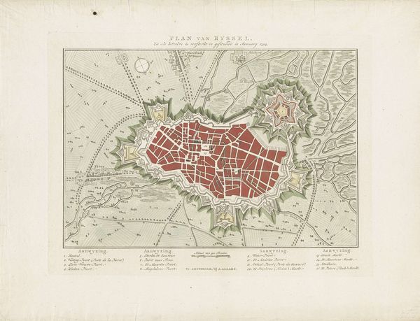
Curator: Before us is a detailed "Plan van de Versterkingen van Douai," or "Plan of the Fortifications of Douai," dating back to 1794. Cornelis van Baarsel created this work using drawing, print, and etching techniques, showcasing the city in meticulous detail. Editor: My first impression? It's beautiful, yet unsettling. All those lines and shapes—it looks like a spiderweb of power and control, with the city at its center, almost trapped. There is such order that, for me, becomes chilling, like an insect encased in amber. Curator: That's a perceptive reading. Maps of this era weren't just about geographical accuracy. They were tools of governance, expressions of power. Note how the fortifications, those star-shaped defenses, dominate the composition. Editor: Right. Each point like a sharp intake of breath. You can imagine them poring over this thing at a war table, planning…strategizing. I like how the reds in the core contrasts so much with the neutral tone around the fortification, like a wound trying to burst forth. Curator: Indeed, the city appears vulnerable despite those elaborate defenses. The fortifications embody Neoclassical ideals: order, reason, control. Yet, they also betray anxiety about invasion and rebellion. Editor: Art imitating Life... Or preparing for Life’s ugly bits. It also makes me think about our digital maps today. We're still mapping and being mapped. How much has changed, really? Curator: It’s a question of how we understand, and how we use our cartographic authority. Here we can also think of the role of the publisher; this particular example printed by J. Allart of Amsterdam and intended for a much wider audience than the governing authorities that commissioned the work. Editor: Yes, makes it feel both hyper-specific, this very place at this very moment, and oddly universal. It’s fascinating. I’m never going to look at Google Maps the same way again! Curator: Precisely! Art offers unique lenses through which we observe and scrutinize societal, military, or urban evolutions; and this 1794 fortification plan is not only a historical object, it is a remarkable manifestation of political, military and creative vision. Editor: Agreed! Who knew a city plan could spark so much contemplation!
Comments
No comments
Be the first to comment and join the conversation on the ultimate creative platform.
More like this