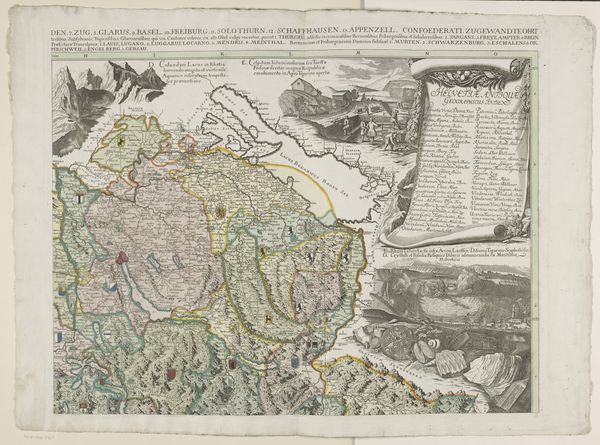
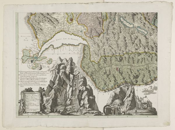
print, paper, engraving
baroque
landscape
paper
cityscape
engraving
Dimensions: height 642 mm, width 762 mm
Copyright: Rijks Museum: Open Domain
Curator: Looking at this detail from Emanuel Schalch's four-part map of Switzerland, dating back to 1712, one immediately appreciates the detail afforded by the engraving on paper. What are your first thoughts? Editor: It's striking, this blend of cartography with allegorical figures. I'm immediately drawn to the socio-political implications embedded in mapping a territory during that era, especially within the context of Swiss identity. The mountains feel imposing, almost romanticized. Curator: The creation of this map as a print demonstrates a specific production process; think about the physical labor involved in engraving, printing, and distributing it. The use of paper as a medium also impacts its accessibility and preservation. These maps are physical commodities reflecting the material culture of the time. Editor: Precisely. Maps are never neutral. Note the deliberate placement of certain cities, or perhaps the absence of others. This reflects power dynamics of the era. It makes me wonder about who commissioned the map, who it was for, and whose voices are missing. Curator: Indeed, these maps facilitated governance, trade, and military planning, marking and controlling resources and populations. The choice of materials itself, the ink and paper, represents accessible technology—cheap enough to reproduce in quantity, yet enduring over centuries. The paper shows some water staining as well. Editor: Yes, but consider the allegorical figures as well. They're not mere decoration; they embody the virtues, perhaps even the perceived ethnic origins, that construct the narrative of “Switzerland” at this moment. The labor shown, the cow herding, the textile manufacturing, it constructs very particular ideals, almost propaganda even. Curator: The very act of mapping— surveying, measuring, then transferring that information to a printed page —demands specialized tools and training. Skills were tightly controlled within guilds, and access to those skills dictated who could participate in these visual representations of space and knowledge. Editor: And consider how these maps reinforce national identity. It isn’t just about geographical location; it’s about defining who belongs and who doesn't. It serves to solidify this nascent idea of a nation. Who’s included? Who benefits? Who gets erased? Curator: When observing this map, its significance expands beyond mere spatial representation and becomes a reflection of the labor, commerce, and culture ingrained within early 18th century Switzerland. The materiality intertwines directly with societal narratives. Editor: Absolutely. Analyzing this piece, considering both the geographic accuracy and its socio-political statements, the interplay between materials and symbolic messaging really comes into sharp focus, revealing the ideologies embedded within cartographic practices.
Comments
No comments
Be the first to comment and join the conversation on the ultimate creative platform.