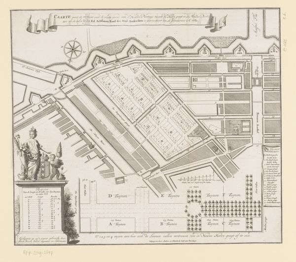
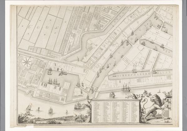
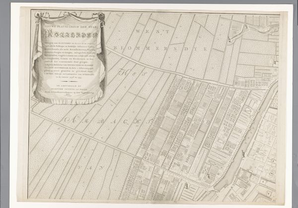
Plattegrond van Wijk 53, nu de Westelijke Eilanden, te Amsterdam 1777
0:00
0:00
casparjacobszphilips
Rijksmuseum
drawing, print, etching, paper, architecture
#
architectural sketch
#
drawing
#
historical design
#
neoclacissism
#
dutch-golden-age
# print
#
etching
#
old engraving style
#
landscape
#
paper
#
architecture drawing
#
cityscape
#
architecture
Dimensions: height 623 mm, width 741 mm
Copyright: Rijks Museum: Open Domain
Curator: This detailed etching by Caspar Jacobsz. Philips, created in 1777, presents a "Plattegrond van Wijk 53," now known as the Westelijke Eilanden in Amsterdam. What strikes you about this piece? Editor: Immediately, it’s the stark precision. The delicate lines mapping the cityscape feel both objective and meticulously crafted. There’s an almost serene order in its composition. Curator: Indeed. As a materialist, I am fascinated by how such precise detail could be achieved through the etching process, consider the labor and materials involved in its creation, and also who this plan was created for. Was it commissioned by the city, perhaps, to manage the bustling port, or for wealthy merchants to track their assets? Editor: From a formal standpoint, notice the careful arrangement of information. The map itself is central, surrounded by a decorative border, inset images, and textual keys. This structured layout conveys authority and a clear hierarchy of visual elements, adhering closely to Neoclassical aesthetics in its pursuit of order and clarity. Curator: Right, Neoclassicism isn't just an aesthetic choice here; it reflects a specific social order and the values of the merchant class that dominated Amsterdam during that period. The plan also reflects Amsterdam's status as a vital hub in the global trade network. Ships from across the world unloaded resources, processed goods and capital and fuelled the wealth of the city. Editor: I’m drawn to how Philips employs line weight and shading to delineate different areas of the city, effectively creating a visual language. The contrast between the detailed map and the simpler, decorative elements allows for both practical understanding and aesthetic appreciation. Also, let’s not overlook how the map situates the neighborhood within its place by representing neighboring geographical and architectural references, emphasizing this location’s role and importance. Curator: Absolutely. The level of detail gives us insight into urban planning and the distribution of resources. The labor that transformed this area to suit their demands is what truly shaped these islands. So looking closely, you begin to realize how wealth and industry altered it into the site captured by Philips. Editor: It’s remarkable how an ostensibly functional object becomes such a rich source of artistic and historical insights when we scrutinize its formal components. Curator: For me, the material object is always entangled within historical process.
Comments
No comments
Be the first to comment and join the conversation on the ultimate creative platform.
More like this