drawing, print, ink, engraving
landscape illustration sketch
drawing
baroque
pen drawing
mechanical pen drawing
pen illustration
pen sketch
landscape
perspective
personal sketchbook
ink
geometric
pen-ink sketch
pen work
sketchbook drawing
cityscape
history-painting
storyboard and sketchbook work
engraving
miniature
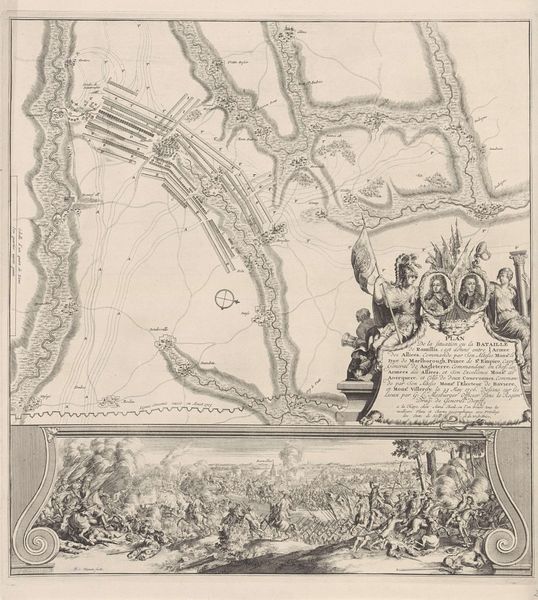
Dimensions: height 144 mm, width 113 mm
Copyright: Rijks Museum: Open Domain
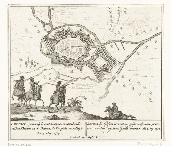
Curator: This print, “Plattegrond van Zoutleeuw, 1705” by Zacharias Chatelain II, really is quite something. Look at that fine linework! Editor: It's amazing! It seems like an overhead map of a town. The level of detail is incredible, especially given its age. What am I missing? What jumps out at you? Curator: It reminds me of an intensely personal yet perfectly orchestrated fever dream! Consider how Chatelain has framed this meticulously drafted map with scenes of its supposed capture by the Allies in 1705, yet bookended by whimsical putti, almost floating above! Are they complicit? Or aloof? Look, the “reality” of the capture fades into near insignificance next to that question, and to the rigid structure of that townscape, the sense of inevitability in it. What do you feel as you examine the town? Editor: It does seem staged. There's an odd disconnect between the violent scene below and the calm map above. Like two completely different worlds existing on the same plane. Curator: Exactly! It's a narrative on multiple levels. Are we seeing history? A bird's-eye perspective? Or something much more intimate? The precision contrasted with the fantastical. What truths do *you* think that contrast reveals? Editor: Hmmm, I'm still pondering, but I see it in a completely new light. The visual contrast underscores this theme by revealing the underlying power dynamics at play. Curator: Precisely, precisely! Maps themselves are power…and dreams, of a sort!
Comments
No comments
Be the first to comment and join the conversation on the ultimate creative platform.