drawing, print, etching, ink
#
drawing
#
baroque
#
dutch-golden-age
# print
#
etching
#
landscape
#
etching
#
ink
#
cityscape
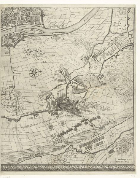
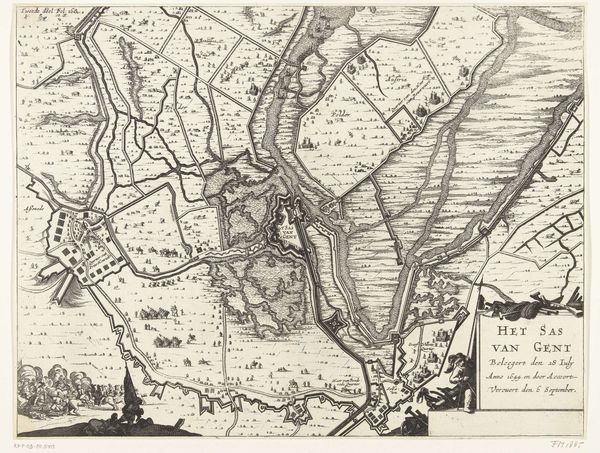
Dimensions: height 400 mm, width 540 mm
Copyright: Rijks Museum: Open Domain
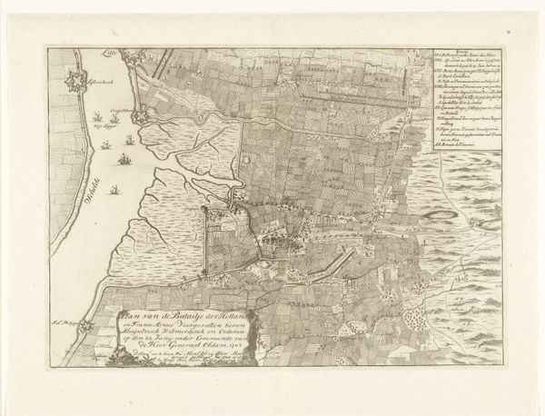
Curator: Looking at this incredibly detailed print, what comes to mind? Editor: Well, my first thought is that it's a bird's-eye view, all very strategic, and emotionally distant. Sort of clinical. Curator: Indeed. We're looking at "The Siege of Breda," from 1637, made by Balthasar Florisz. van Berckenrode. It is meticulously rendered with ink and etching techniques. This piece depicts the intricate layout during a historical military event, the siege of Breda, which occurred during the Eighty Years' War. Editor: An emotionally distant bird surveying a battlefield. I'm struck by how much information is crammed in—fields, waterways, fortifications. It’s like a game board waiting for the next move, the next great play. So how was the conflict reflected in artistic perspectives at that time? Curator: These cartographic depictions weren't only geographical aids. They symbolized power and control, underscoring Dutch military prowess, of course. But it gets more intriguing once we consider these prints had wider public distribution. Prints like these shaped popular views on the war; each citizen could literally study strategy from their parlor! The map becomes a political tool as much as a picture. It puts everyone on the war council, or so they may have felt at that time. Editor: So it is strategic PR too. Look at how everything is so neatly arranged; those orderly fields, everything tidily labeled. Did life during war look that well-ordered for common folk? Is this how it really looked, or a stylized vision crafted for effect? Curator: Probably closer to crafted. Consider its purpose: boosting morale, justifying immense war expenses. These landscape-maps showed order rising out of conflict—a powerful symbolic reassurance at a pretty stressful moment. Editor: It makes me think about how we, as a public, receive these images as fact. This map isn't just about recording a past event, it's a record of how the conflict was pitched to, and perceived by, those far away from the siege lines. Curator: Precisely! It encapsulates a crucial phase in solidifying national pride, offering what was actually a carefully constructed narrative about state power and the look and feel of dominance during that particular point in time. Editor: That is fascinating. All that emotional territory disguised in lines and grids. Looking closer definitely opened up a bigger battle than is pictured here. Curator: Maps like this continue teaching about strategy in the historical theatre.
Comments
No comments
Be the first to comment and join the conversation on the ultimate creative platform.
More like this