drawing, print, ink, engraving
drawing
medieval
baroque
old engraving style
landscape
ink
geometric
cityscape
history-painting
engraving
Dimensions: height 271 mm, width 345 mm
Copyright: Rijks Museum: Open Domain
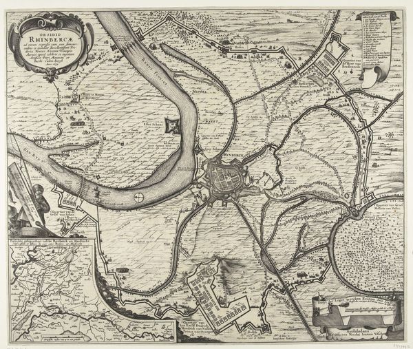
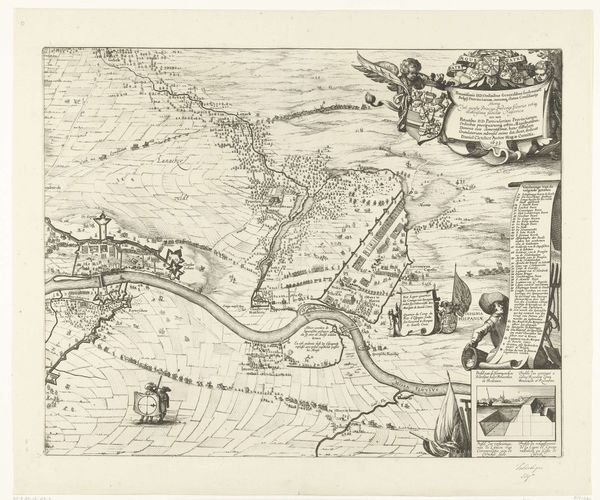
Editor: This engraving from 1651 to 1652, titled "Kaart van het beleg van Rijnberg, 1633," shows the cityscape and landscape surrounding Rijnberg. The level of detail is incredible, almost overwhelming! I'm immediately curious about the reason someone would go to such lengths to document this. What stands out to you about this piece? Curator: This print is far more than just a depiction of Rijnberg; it's a statement about power and control during a tumultuous time. Military maps such as these served vital functions beyond mere orientation. What purposes could this rendering have served, considering that it was created almost twenty years *after* the depicted siege of 1633? Editor: Well, it looks pretty. Was this just for historical record, a way of showing events like they were in real life? Curator: It certainly serves a historical purpose, memorializing the siege of Rijnberg, however, consider the social and political implications. These kinds of engravings reinforced Dutch power and resilience during a period of ongoing conflict. Disseminated as prints, images of successful sieges not only documented history but also cultivated national pride and solidified political authority. Do you think such a map would give insight on the event portrayed to contemporary viewers? Editor: It’s like visual propaganda, in a way. But wouldn't a printed map accessible to the public reduce its use for defense purposes, or does its aesthetic value hold another kind of political value that surpasses its informational liability? Curator: Exactly. The very act of creating and distributing this image reinforced the Dutch Republic's authority. Now think about the influence of the printing press itself in solidifying narratives! This wasn't just a map; it was a tool used to influence public opinion, legitimise rule, and craft collective identity through readily distributable images. Editor: I never really thought about maps being used that way. It makes you question how much history is a matter of record versus a tool to solidify those in charge. Curator: Precisely! Understanding art like this helps us understand how visual media shapes and reflects our understanding of history.
Comments
No comments
Be the first to comment and join the conversation on the ultimate creative platform.