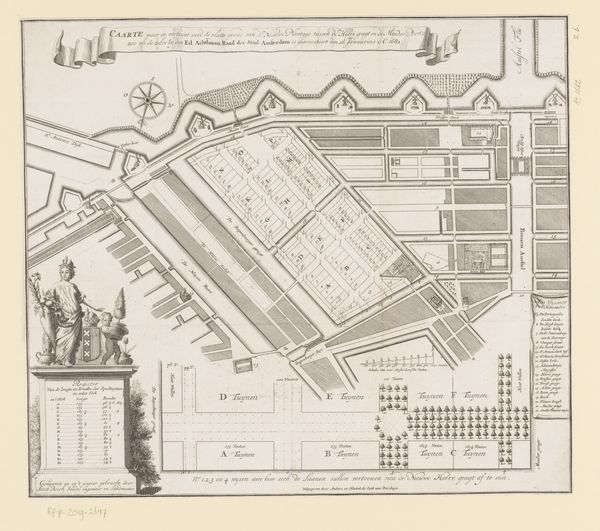
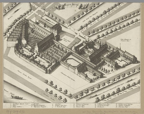
Plattegrond van burgerwijk nummer 7 te Amsterdam, onder leiding van kapitein Jan de Lange after 1734
0:00
0:00
print, etching
#
baroque
# print
#
etching
#
old engraving style
#
cityscape
Dimensions: height 486 mm, width 665 mm
Copyright: Rijks Museum: Open Domain
Curator: Here, we have "Plattegrond van burgerwijk nummer 7 te Amsterdam, onder leiding van kapitein Jan de Lange," an etching, most likely a print, dating from after 1734. Editor: Whoa, I immediately get a kind of stoic, old-world feeling from this. Like a meticulously planned chessboard frozen in time. It's intense, formal, but also kind of cool. Curator: It presents a formal, structured depiction of Amsterdam’s burgerwijk number 7, district number seven, under the direction of Captain Jan de Lange. The meticulous detail is very much aligned with Baroque conventions, embracing precision and complexity in its rendering of the urban space. Editor: It's not just precise, it's ornate! The coats of arms, those little cherubs. But the severity of the street layout and building masses bring me back to earth. Curator: The composition employs a hierarchical layout; cartographic symbols provide structure and legibility, while decorative heraldry enriches its visual complexity, fulfilling functional and aesthetic purposes simultaneously. Editor: But it’s so rigid! I imagine this district being extremely organized and strict—I mean, the thing is nearly symmetrical. Does the regularity offer a symbolic element? I almost sense some political message woven in there? Curator: Yes. These maps functioned as more than geographic representations. They imposed order, clarified property boundaries, and reinforced the existing socio-political power structure of the era. The order that you notice underscores and reaffirms stability. Editor: So it is propaganda, but beautiful propaganda. To me, it's strangely calming despite the rigidity and the serious aura of "planning." There's something oddly poetic about that control— the attempt to tame life into a perfect design. Curator: Agreed, this baroque map encapsulates the ambitions and aesthetics of its time, masterfully articulating authority through cartography and civic pride with fine, calculated line work and symbolism. Editor: Seeing the etching in this manner allows me to appreciate not only its practical applications, but also its power as an artifact, as an expression of ideals. This map reveals something timeless.
Comments
No comments
Be the first to comment and join the conversation on the ultimate creative platform.
More like this