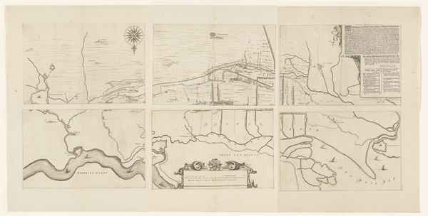
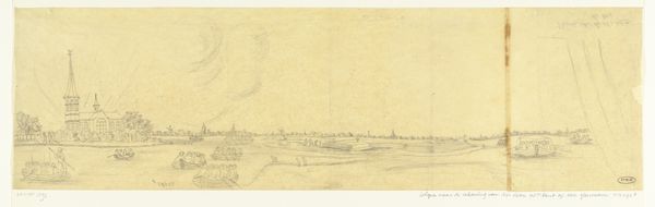
Kaart van het gebied tussen Den Bosch en Geertruidenberg met dijkdoorbraken (tweede blad) before 1757
0:00
0:00
drawing, print, etching
#
drawing
#
medieval
#
dutch-golden-age
# print
#
etching
#
landscape
#
etching
#
geometric
#
line
Dimensions: height 306 mm, width 462 mm
Copyright: Rijks Museum: Open Domain
This map was made by an anonymous artist, depicting the area between Den Bosch and Geertruidenberg, and the dike breaches there. It's rendered using ink on paper, a traditional method for cartography at the time. Notice how the ink, applied with precision, delineates the landscape, mapping not just geographical features but also human interventions like dikes. The paper itself, likely handmade, provides a textured ground for the detailed linework. The choice of materials speaks to a culture deeply invested in understanding and controlling its environment. The map's social significance lies in its representation of a landscape shaped by both natural forces and human labor. The dikes, meticulously drawn, stand as testaments to the collective effort required to reclaim land from the sea. This wasn't just a matter of technical skill, but of social organization. The work challenges our conventional ideas about art and craft, revealing the inherent artistry in functional objects. The map's intricate details and deliberate composition invite us to appreciate its aesthetic qualities, while its practical purpose reminds us of the intimate connection between human creativity and our material world.
Comments
No comments
Be the first to comment and join the conversation on the ultimate creative platform.
More like this