print, paper, engraving
#
baroque
# print
#
landscape
#
paper
#
cityscape
#
engraving
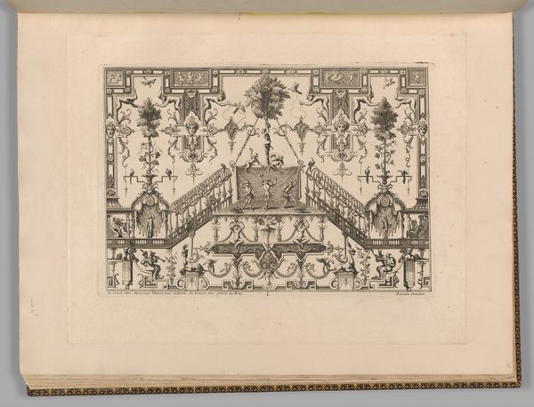
Dimensions: height 382 mm, width 450 mm, height 536 mm, width 620 mm
Copyright: Rijks Museum: Open Domain
Editor: Here we have "Plattegrond van kasteel en tuinen van Versailles", or "Map of the castle and gardens of Versailles", a print on paper by Adriaen Schoonebeek, made between 1677 and 1705. Looking at the intricate layout, the whole piece seems like an elaborate stage setting, almost theatrical. What do you make of this incredibly detailed depiction, with all its baroque grandeur? Curator: Oh, it's delicious, isn't it? Schoonebeek’s engraving isn’t just a map; it’s a portrait of power, ambition, and a kind of… well, controlled madness, maybe. Those precisely arranged gardens aren't just pretty; they are Louis XIV flexing on nature itself, forcing it into submission with those insane geometries. And those little allegorical figures along the sides! It’s pure theatre as you said, projecting dominance. It's an architectural daydream pressed onto paper, isn't it? Editor: Definitely! I'm curious, what do you think it says about Louis XIV’s personality, that he wanted everything to be so symmetrical and controlled? Curator: Control, darling! Think of it as… therapy, writ large in hedges and fountains. Louis, like any of us, was battling chaos, inner and outer, constantly, and this map shows Versailles as his weapon, or his balm. Maybe a little of both? The king taming his anxieties with a straight edge. Does that make sense? It is deeply telling when humans, then and now, are working this hard on the world around them. Editor: Absolutely! It makes you wonder what anxieties we try to "tame" today with our own creations, digital or otherwise. Thank you. Curator: A tasty morsel for thought! Glad to ponder with you!
Comments
No comments
Be the first to comment and join the conversation on the ultimate creative platform.
More like this