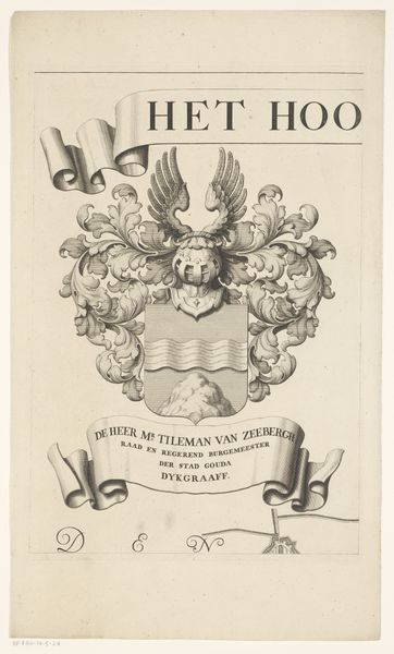
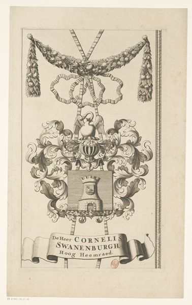
Kaart van het Hoogheemraadschap van de Krimpenerwaard (deel wapenrand) 1683 - 1741
0:00
0:00
graphic-art, print, paper, engraving
#
graphic-art
#
baroque
#
dutch-golden-age
# print
#
paper
#
geometric
#
line
#
history-painting
#
engraving
Dimensions: height 439 mm, width 295 mm
Copyright: Rijks Museum: Open Domain
Curator: This is a fragment of "Kaart van het Hoogheemraadschap van de Krimpenerwaard," a print made sometime between 1683 and 1741, during the Dutch Golden Age. It offers insight into the region’s water management. Editor: My initial reaction is that there is a striking formality here; the lines are sharp, and there's a sense of intended, perhaps imposed, order and hierarchy. Even this cropped segment suggests larger systems at work. Curator: Precisely. This map fragment gives us a window into Dutch identity, a period marked by a constant struggle against the sea. You can see that played out in the central symbol: a prominent anchor. Consider how the print may reflect a deep investment in infrastructure as a form of collective identity during the Golden Age. Editor: Yes, the anchor immediately conveys maritime power and stability. However, the addition of an angel figure suggests a reliance on divine favor, or perhaps a sense of the natural world’s unpredictability needing constant supplication. There's a certain tension, isn’t there? This negotiation between human will and uncontrollable forces. Curator: The flowing ribbon and stylized leaves speak to the baroque sensibility, highlighting status and wealth alongside the very practical function of this "kaart" as a land management tool. These visual components serve to legitimize the authority of those who govern the region’s precious waterways, further emphasizing power and influence through an established hierarchy. Editor: Absolutely. The heraldic quality, along with that rather grand inscription about "De Heer Cornelis Vander Hoop", anchors this document to a very specific social structure. It makes you consider, doesn't it, who exactly held the power to shape not only the landscape but also its representation. Curator: Seeing the names attached to territory transforms it from a mere piece of land into something loaded with social implications and economic potential. Reflecting on this, it urges one to see historical mapping practices as tools of power with lingering implications for concepts such as private and shared spaces. Editor: Ultimately, observing the way cultural memory weaves together emblems of strength, vulnerability, and authority leads to some very profound questions about our relationship to the spaces we inhabit and the systems that control them.
Comments
No comments
Be the first to comment and join the conversation on the ultimate creative platform.
More like this