print, paper, ink, engraving
#
dutch-golden-age
#
ink paper printed
# print
#
landscape
#
paper
#
ink
#
geometric
#
engraving
Dimensions: height 110 mm, width 156 mm
Copyright: Rijks Museum: Open Domain
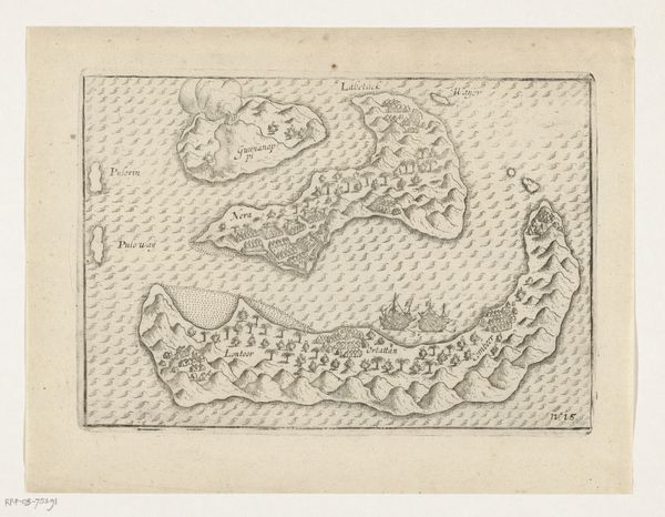
Curator: Welcome. We're looking at a print from the Dutch Golden Age called "Kaart van de Banda-eilanden," dating roughly from 1600 to 1645, the work of an anonymous artist. It's currently held in the Rijksmuseum. Editor: My first thought? Restless exploration. There's something about those craggy coastlines rendered in ink, the imagined ships frozen mid-voyage, it stirs the heart, doesn't it? Gives you that "itchy feet" feeling. Curator: Absolutely. The Dutch interest in the Banda Islands was driven by the spice trade, specifically nutmeg and mace. This map served a political and commercial function, representing both knowledge and a claim. It’s as much about projecting power as charting territory. Editor: Right! And it's incredible to think how valuable these islands were back then. Seeing it now, it just looks like a drawing of a few rocks in the sea, almost innocent. But it’s anything but. Curator: Precisely. These islands were the site of intense conflict between the Dutch and the native population, leading to a grim chapter in colonial history. The seemingly simple rendering belies the immense violence that unfolded there. Editor: Look at the tiny buildings huddled along the coasts, they’re almost decorative. It’s strange how cartography, intended to bring order and clarity, often conceals the messy realities underneath. It sanitizes history, doesn’t it? Curator: Maps such as this, intended to present a logical view of a landscape, are often layered with ideology and power. Editor: It makes me wonder about all the perspectives missing from this image – the stories of the indigenous people erased, the hidden tragedies in those tiny houses. Maybe that restless feeling I got initially was actually a subconscious tremor of discomfort, a ghost in the ink. Curator: Perhaps. What appears clear-cut in the image carries an ambiguity of untold stories. It's the kind of map that invites us to navigate not just a place but also a past, filled with implications and a painful reality. Editor: Well, it definitely has me thinking. The picture might be simple, but the history is complex. Thanks for pulling us closer.
Comments
No comments
Be the first to comment and join the conversation on the ultimate creative platform.
More like this